


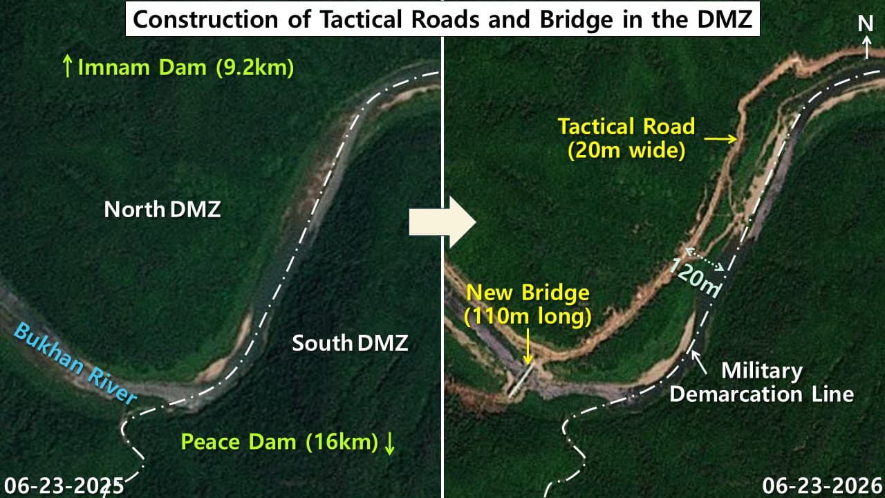
I analyzed commercial satellite imagery from the United States and Europe to see how North Korea’s side of the Demilitarized Zone, or DMZ, has changed. A large scale military construction campaign is reshaping the area. Since 2024, North Korea has fortified the northern side of the DMZ. It has built tactical roads and bridges and installed barriers and barbed wire fences. My review of the images found a new 20 meter wide road along the Bukhan River. I also found a new bridge there, roughly 110 meters long. I assess this infrastructure is meant to speed the movement of troops and military equipment.
I also used satellite data to analyze land use changes inside the DMZ in 2026. The construction has cleared a stretch of forest nearly 49 times the size of Yeouido, the Seoul island that covers about 290 hectares. That forest has been replaced by grassland or damaged terrain. North Korea’s construction is eroding the DMZ’s role as a buffer zone, which means even a small accident could raise military tension amid already fraught inter-Korean relations. The DMZ has long been untouched by human activity and prized as an ecological reserve. Military construction is now damaging it, which makes continued satellite monitoring and close observation necessary.
North Korea’s construction inside the DMZ
I compared satellite images from the U.S. commercial satellite operator Planet Labs, which has a resolution of three meters. I confirmed that North Korea built a new tactical road roughly 20 meters wide along the northern bank of the Bukhan River. The river runs along the Military Demarcation Line, or MDL, through the DMZ near Gwahodong in Gimhwa county, Kangwon province. The road connects to a section that runs parallel to the river about 120 meters from the MDL. I also observed the new bridge spanning the Bukhan River there. The river starts at the Imnam Dam, also known as the Kumgang Dam, nine point two kilometers upstream. It flows through the DMZ. From there it continues south to the Hwacheon Reservoir by way of the Peace Dam. I assess North Korea is steadily expanding infrastructure inside the DMZ. The goal appears to be increasing the mobility of its troops and equipment.
Land use changes across the DMZ
I used land cover data from the European Space Agency’s Sentinel-2 satellite to analyze land use changes and environmental damage inside the DMZ. Since 2024, North Korea has built tactical roads and bridges there. It has also installed barriers and laid landmines. To capture how these projects have reshaped the terrain, I compared land use data with a resolution of 10 meters from 2024 and 2025. Land use data for 2026 is not yet available, so I could not include it in this analysis.
For this analysis, I created a GIS vector dataset that defines the DMZ as a four kilometer wide band. It applies a two kilometer buffer on either side of the Military Demarcation Line, which serves as the reference line. This differs somewhat from the DMZ as it functions today. South Korea and North Korea each maintain their own southern and northern boundary lines, and the width and shape of the buffer vary by section.
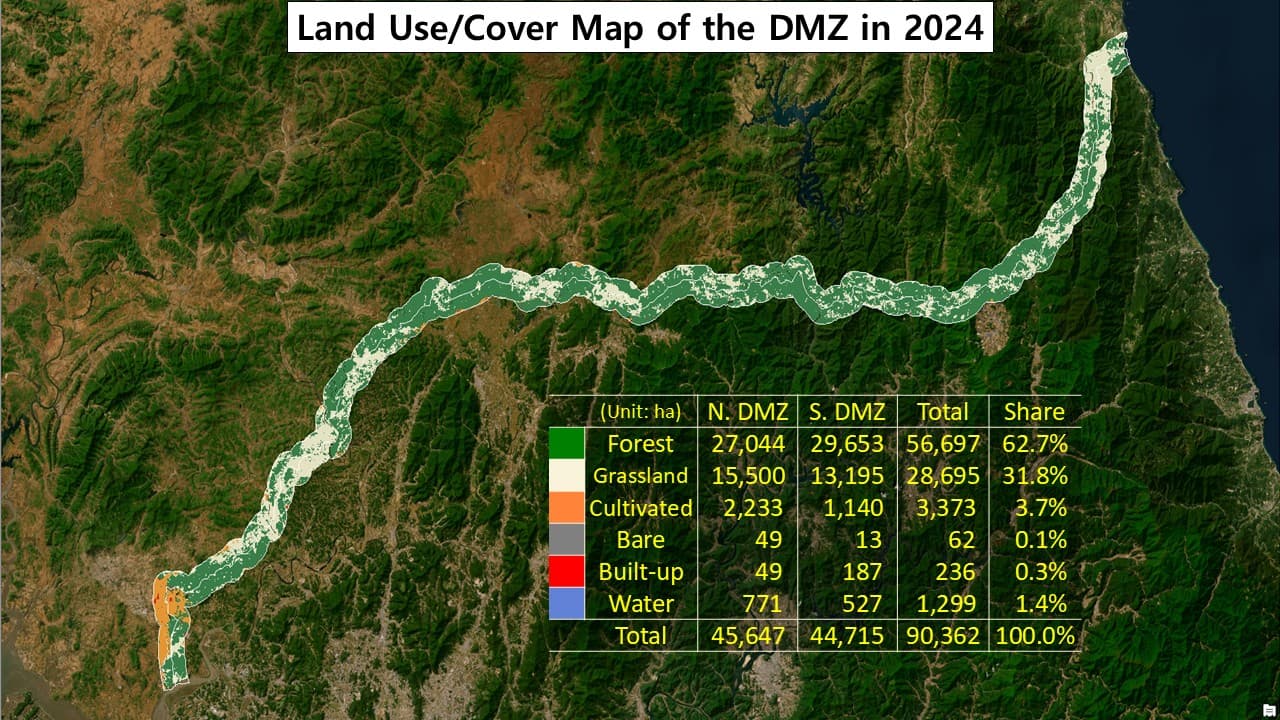
I found that the DMZ’s total area measured about 90,362 hectares in 2024. That is roughly one and a half times the size of Seoul, which covers about 60,521 hectares. This figure comes from a computer calculation based on satellite imagery, so it may differ somewhat from the actual area. The northern side of the DMZ covered 45,647 hectares. The southern side covered 44,715 hectares. That means the northern side is about 932 hectares larger.
By land use type, forest accounted for the largest share at 56,697 hectares, or 62.7%. Grassland followed at 28,695 hectares, or 31.8%. Combined, forest and grassland made up 94.5% of the DMZ. Most of the zone remained natural environment. Cropland accounted for 3.7%, and artificial structures made up just 0.3%. Those structures consist mainly of the South’s Daeseong-dong, known as Freedom Village, and the North’s Kijong-dong, known as Peace Village, near Panmunjom, along with a small number of military facilities. Most of the cropland is also concentrated around these civilian settlements.
My analysis of 2025 data found that forest cover had fallen to 42,482 hectares, or 47.0% of the total area. That is a decline of 14,215 hectares, or 25.1%, from 2024. Grassland expanded to 42,845 hectares, or 47.4%. That is an increase of 14,150 hectares, or 49.3%, from the previous year. Forest declined while grassland classifications increased. I read this shift as a sign of forest damage from North Korea’s tactical road and barrier construction and its landmine laying activities since 2024.
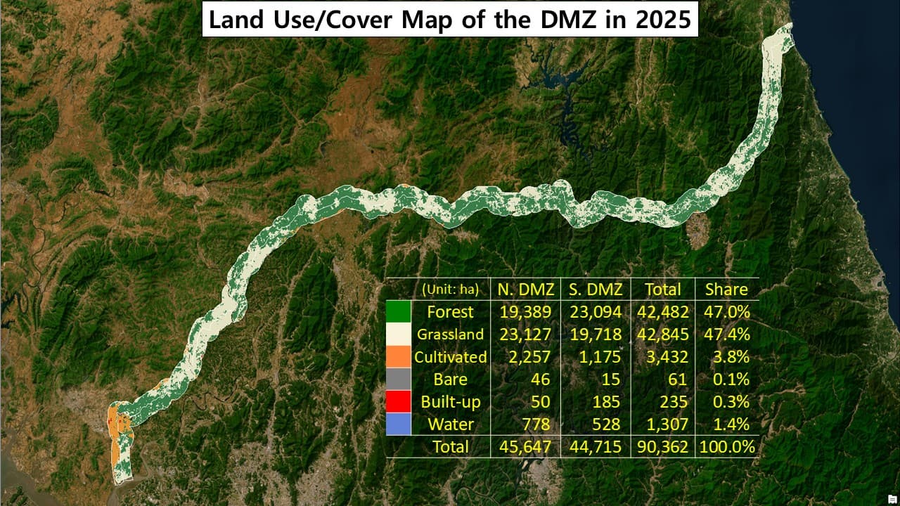
Comparing the DMZ’s land use in 2024 and 2025, I found that forest area decreased while grassland increased over the year. The lost forest area is equivalent to about 49 times the size of Yeouido. This shift lines up with the period since 2024 when North Korea ramped up construction of tactical roads and bridges. It also installed barriers and laid landmines inside the DMZ during this time. I believe that activity likely contributed, at least in part, to the decline in forest and the rise in grassland.
Changes in land use/cover in the DMZ
Unit: hectares
| Class | 2024 | 2025 | Change |
|---|---|---|---|
| Forest | 56,697 | 42,482 | −14,215 |
| Grassland | 28,695 | 42,845 | +14,150 |
| Cultivated | 3,373 | 3,432 | +59 |
| Bare | 62 | 61 | −1 |
| Built-up | 236 | 235 | −1 |
| Water | 1,299 | 1,307 | +8 |
| Total | 90,362 | 90,362 | 0 |
Security implications of the construction
North Korea has continued fortifying the northern side of the DMZ. It has installed barbed wire fences and landmines and built tactical roads and bridges. The satellite imagery shows cleared trees and grass, opening movement corridors, along with new infrastructure that lets troops and equipment move quickly. This construction has continued across multiple sections of the DMZ since 2024. Roads and fencing now extend closer to the Military Demarcation Line. I see this as part of a broader effort to tighten surveillance and control.
Militarily, I assess that the tactical roads and bridges improve North Korea’s mobility and defensive capability. They ease the movement of troops, equipment and supplies. Based on the construction confirmed so far, it is difficult to conclude that North Korea is deliberately preparing a specific military threat. The fences, landmines and barriers are mainly defensive and are meant to block access. The tactical roads and bridges likewise appear to support defense and movement. For now, I give more weight to a different interpretation: North Korea appears to be managing the Military Demarcation Line as a de facto border and tightening control along it. Going forward, it will be important to keep watching whether large troop concentrations or offensive equipment show up at the front line.
This construction can also be read as the military expression of North Korean leader Kim Jong Un’s doctrine describing the two Koreas as hostile states. South Korea’s military views these activities as weakening the DMZ’s function as a buffer zone, and may also run against the intent of the Armistice Agreement. The United Nations Command sees it differently. It maintains that the construction cannot immediately count as an armistice violation unless direct military actions are confirmed, such as crossing the Military Demarcation Line or deploying heavy weapons. It is difficult to conclude that the current construction has sharply raised the immediate military threat. Still, I assess that the risk of an accidental clash could grow. The DMZ’s buffer function keeps eroding, and inter-Korean tension keeps rising, so close monitoring and thorough preparedness by South Korea’s military are needed now more than ever.
August 10, 2026 at 04:17AM
by DailyNK(North Korean Media)