


Recent high-resolution satellite imagery shows that the sludge-covered area within a settling pond at North Korea’s Pyongsan uranium concentration plant grew by about 0.8 hectares, roughly the size of one and a half soccer fields, over approximately nine months in 2026. Sludge is the dark residue left behind after uranium ore is processed into yellowcake, a solid form of uranium oxide used to make nuclear fuel.
The expansion suggests refining activity has continued and may have increased recently at the Pyongsan facility, a development that stands out given North Korea’s push to expand its capacity to produce nuclear material. We also found that the growing volume of sludge appears to be placing significant strain on the plant’s existing storage and treatment capacity.
Dark liquid released through a floodgate at the settling pond travels roughly 1.1 kilometers through a drainage channel before forming a 1.14 hectare pool, or auxiliary reservoir, in low-lying terrain downstream, an area roughly the size of two and a half soccer fields. We identified signs that the water then flows through a roughly 90-meter underground channel and along a small stream toward the main course of the Yesong River.
The pool, which shares the settling pond’s dark green to black coloring, appears to serve as a temporary holding area for material discharged from upstream. Because it lies just one to 1.5 kilometers from the Yesong River and consists of a simple earthen barrier rather than a sealed containment structure, heavy monsoon rain could cause it to overflow, breach or leak through the soil, potentially allowing pollutants to reach the river system. We believe continuous, high-resolution satellite monitoring is needed to detect and respond to the risk of wastewater contamination spreading.
Pyongsan county’s uranium concentration plant, located in North Hwanghae province, is one of North Korea’s principal facilities for producing nuclear material. The plant treats ore with sulfuric acid and other chemicals to produce yellowcake. The process leaves behind acidic wastewater and sludge, a muddy, dark residue that remains after uranium has been extracted.
Unlike the green liquid wastewater, the sludge forms a thick, dark green to black solid layer that is clearly distinguishable and is collected in a large settling pond for storage and further settling. Tracking the condition of the pond and the pattern of sludge accumulation is one of the main ways we gauge changes in the plant’s operations and production.
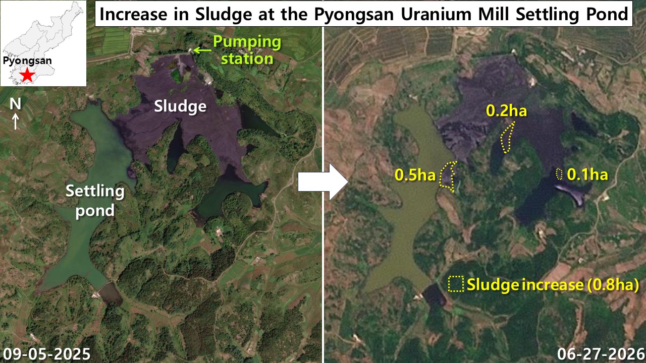
Comparing satellite images from Sept. 5, 2025, and June 27, 2026, we found that the area of dark solid residue left after uranium refining within the settling pond expanded by a total of about 0.8 hectares, or roughly the size of 1.1 soccer fields, over about nine months.
A new 0.5-hectare layer formed along the pond’s western edge, while we identified an additional 0.2 hectares of buildup in the central deposit area and 0.1 hectares in the eastern drainage zone, indicating that sediment accumulation is proceeding rapidly across the pond. The continued expansion of these sludge deposits suggests a considerable increase in the burden on the pond’s storage and treatment capacity, although satellite imagery alone cannot confirm the pond’s exact depth, its total storage capacity or how much treatment capacity remains.
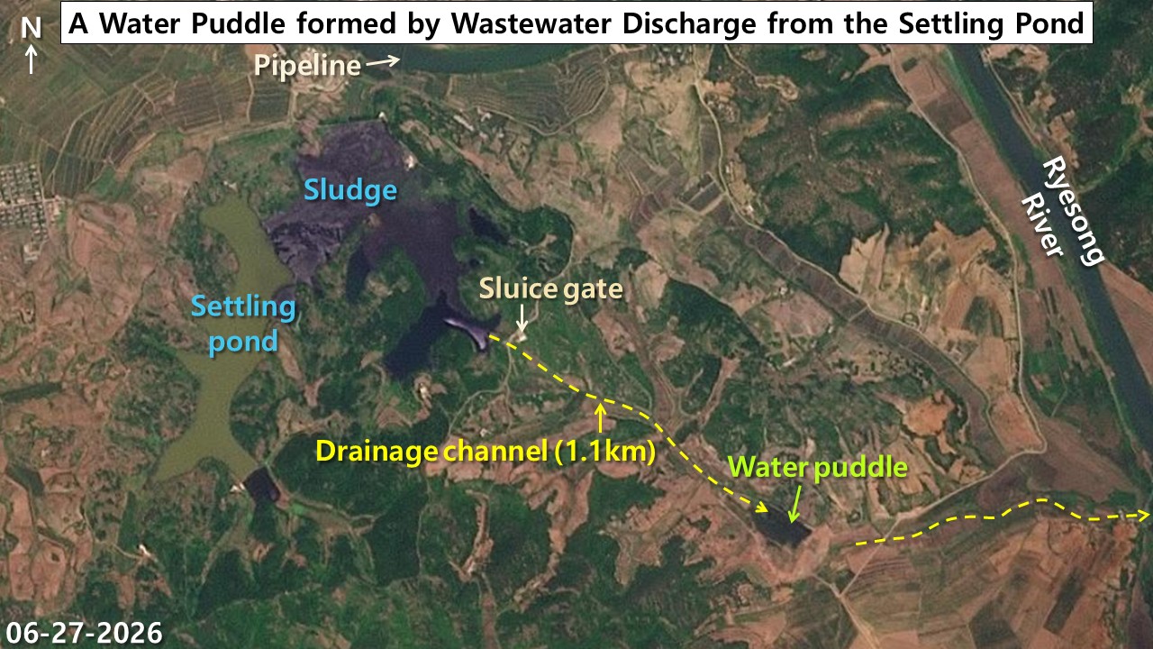
In imagery from June 27, we observed dark liquid being released from the settling pond’s floodgate facility into a downstream drainage channel. The liquid flowed roughly 1.1 kilometers along a valley drainage channel before pooling behind a barrier embankment in a low-lying basin downstream.
Sediment that appears to have flowed in with the liquid since early February accumulated over several months and settled, forming a large auxiliary reservoir. Given the recent sharp increase in sludge accumulation at the upstream pond, this downstream discharge may be linked to growing pressure on the pond’s storage and treatment capacity.
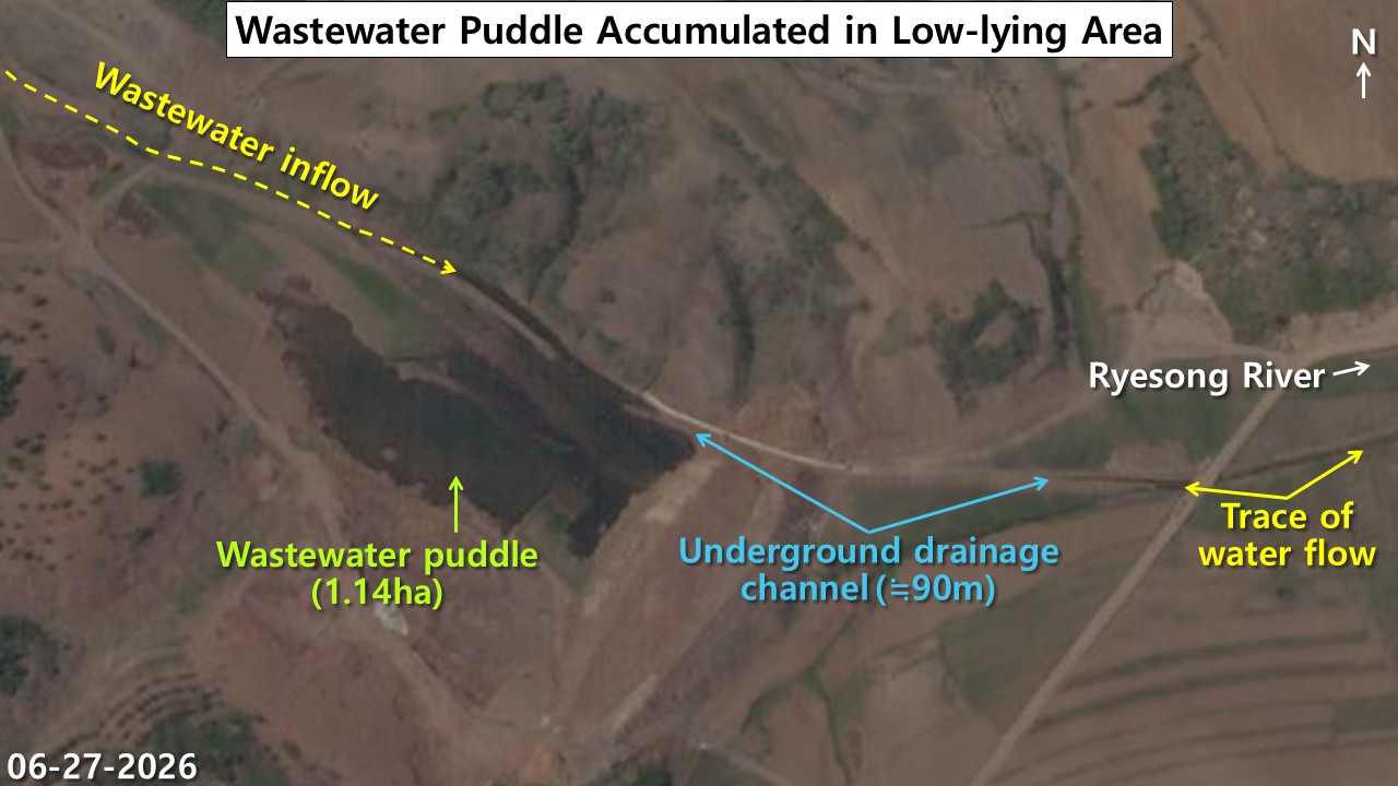
The pool that formed downstream along the small stream shares the same dark green tone as the upstream settling pond, and we identified what appears to be sediment collected at its bottom, a sign that material from the upstream pond may be moving through the drainage channel and accumulating downstream. We also identified signs of water flow continuing from the pool along the stream channel toward the main course of the Yesong River to the east, underscoring the need to examine whether material from the Pyongsan plant’s waste treatment process could migrate into the downstream river system. A roughly 90-meter underground channel, built with buried piping and covered with soil, connects the pool to the small stream on its eastern side, according to a July 8, 2025, article from SI Analytics, a commercial satellite imagery analysis firm.
Risk of Yesong River contamination
Our analysis found that as sludge accumulation increased sharply at the Pyongsan uranium plant’s settling pond, material that appears to have leaked through the drainage channel is pooling in a downstream auxiliary reservoir just one to 1.5 kilometers from the main course of the Yesong River. The low-lying basin itself slopes toward the river, and the small stream running through it also flows in that direction.
The similarity in color between the downstream pool and the upstream settling pond, combined with the drainage route we identified connecting the two points, raises the possibility that material discharged upstream has traveled downstream.
The pool appears to temporarily contain the material that flows into it, but it functions more as a simple embankment than a fully sealed containment structure. If water levels rise during heavy monsoon rain, the pool could overflow or its low embankment could collapse, allowing the stored material to move through the downstream river system toward the Yesong River. Additional leakage through soil seepage or damage to drainage infrastructure also cannot be ruled out.
Satellite imagery alone cannot confirm the composition of the material in the downstream pool or whether pollutants have actually reached the main course of the Yesong River. Continuous, high-resolution satellite monitoring will be needed going forward to track whether material is entering the river system and to monitor changes at the downstream reservoir.
August 18, 2026 at 11:31PM
by DailyNK(North Korean Media)