


Satellite imagery shows yellow-tinted mine drainage spreading from North Korea’s Bupo mine toward farmland and a saltworks in South Hwanghae province’s Kangnyong county, with the contaminated runoff reaching waterways connected to Kangnyong Bay and raising concerns it could eventually leak into the Yellow Sea.
The mine’s drainage flows toward the Bupo reservoir and nearby farmland, likely affecting soil and water quality along the way. If the runoff reaches the Bupo saltworks, it could also disrupt salt production there. Of particular note, the tidal flat waterways near the mine connect to Kangnyong Bay through drainage sluice gates on the coastal embankment, raising the likelihood that the mine’s drainage is reaching the sea. Pollutants that flow into the Yellow Sea through Kangnyong Bay could spread to surrounding waters under the influence of tides and coastal currents. Whether the contamination actually reaches South Korean waters such as Gyeonggi Bay, however, would require verification through precise ocean current modeling. If heavy metals do accumulate along the coast, it could raise safety concerns for seafood and salt.
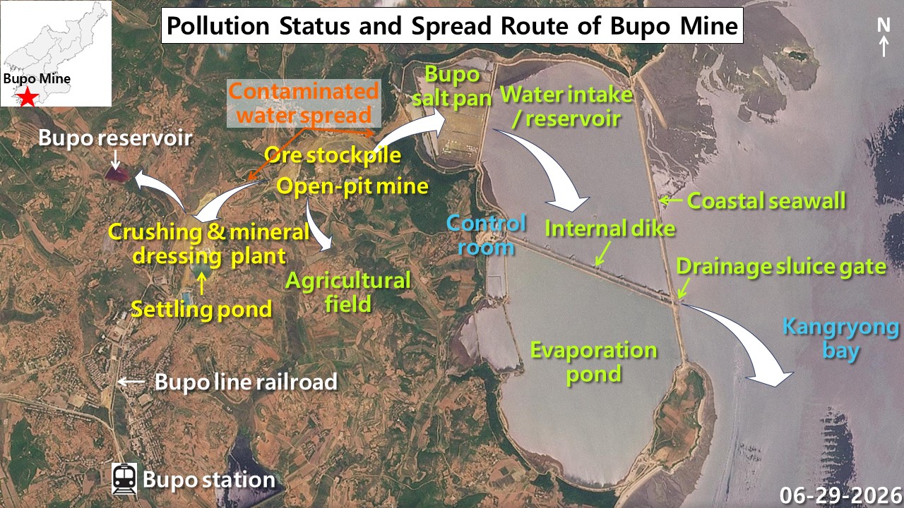
The Bupo mine, located in Bupo village in Kangnyong county, is a major gold and copper production site. Development and expansion of the mine began in earnest in the early 1970s to process the ore being extracted there. Its importance was underscored in 1972, when North Korea built the Bupo Line (a rail line laid to move ore) connecting the nearby town of Singangnyong with Bupo. The mine has long operated large scale extraction and processing facilities, including an open pit and a mineral processing plant, to produce nonferrous metals. Satellite images also show waste rock and ore piled in open areas around the mine. When such mine tailings are exposed to rainwater over long periods, they can generate acid mine drainage (acidic runoff laden with metal contaminants) depending on the mineral composition of the ore.
History of the Bupo saltworks
The Bupo saltworks near the mine were first developed on a large scale in the late 1930s, during Japan’s colonial rule of Korea, when the wide tidal flats along the west coast were reclaimed to produce salt through solar evaporation. After Korea’s liberation, North Korea expanded the embankments and gradually reclaimed and repaired internal channels, evaporation ponds and intake reservoirs through the 1950s and 1960s to boost self sufficiency in salt and secure raw materials for industrial use, eventually forming today’s large scale saltworks system. Recent satellite images show traces of yellow-tinted drainage and sediment, apparently originating from the Bupo mine, running along waterways and tidal flats near the mine toward the saltworks. This raises the possibility that the mine’s drainage is affecting the saltworks and the surrounding tidal flat waterways.
The Bupo saltworks is laid out within a production zone enclosed by a large coastal seawall that blocks tides from the open sea and an inner embankment that regulates water depth. In the saltworks’ northwestern section, intake and storage reservoirs that collect seawater to raise its salinity, along with a grid of evaporation ponds that evaporate the brine in stages, are precisely divided by earthen berms. Along the embankment’s coast, drainage sluice gates and a control facility that manage the inflow and outflow of seawater are installed. The saltworks sits right next to the Bupo mine’s open pit and stockyard to its west, and satellite images show signs of yellow-tinted mine drainage seeping into it.
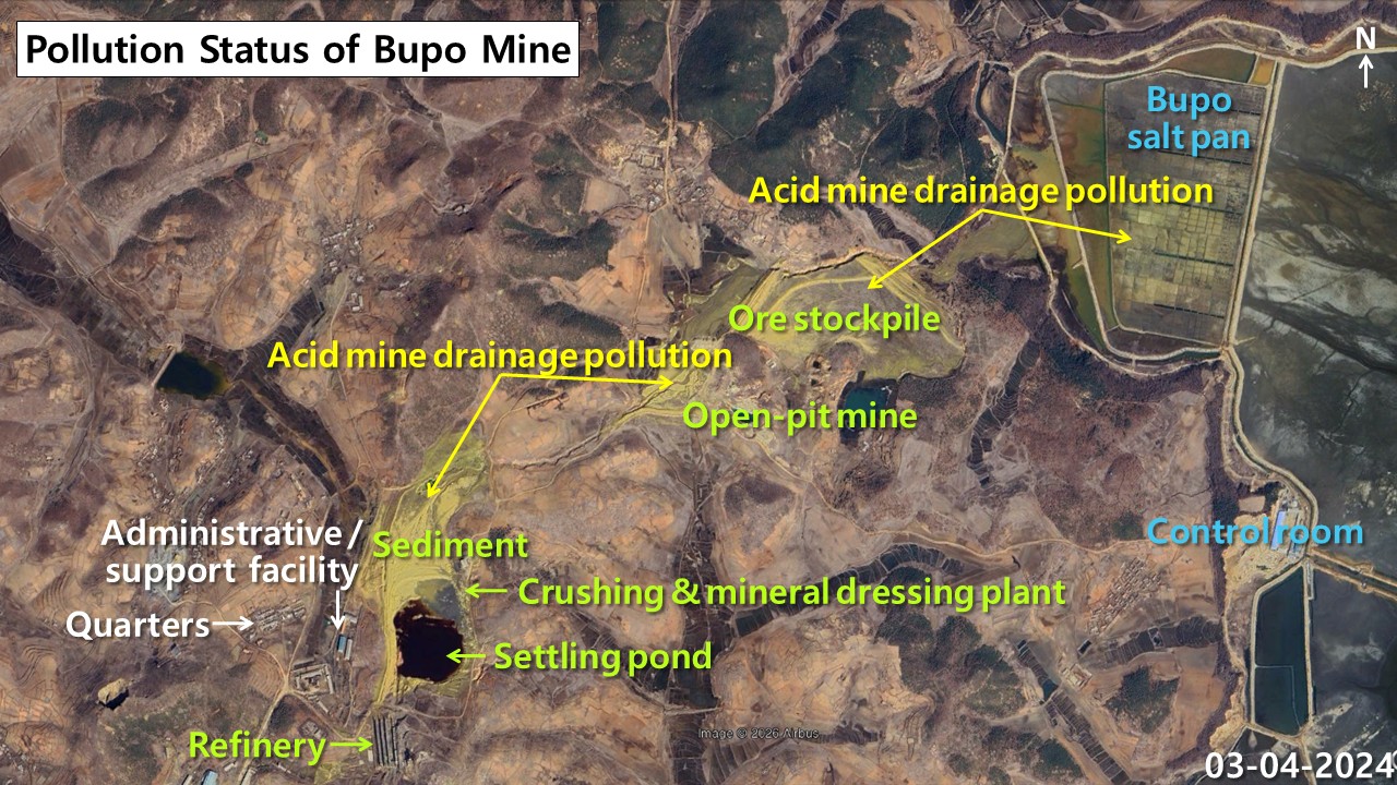
Around the mine’s open pit and mineral processing plant, satellite images show flows of yellow-green and intensely yellow drainage and sediment, apparently generated when abandoned ore reacts with rainwater. This drainage appears to spread along waterways after passing through sedimentation and deposition areas at the center of the mine. Because the tidal flat waterways connect to Kangnyong Bay through drainage sluice gates, there is also a possibility that the pollutants are reaching the sea.
Acid mine drainage can contain iron and various other heavy metals, raising concerns about harm to the surrounding soil and aquatic ecosystems. If heavy metals actually flow into and accumulate in the saltworks or coastal waters, it could also raise safety concerns for solar salt and seafood. However, the types and concentrations of heavy metals in the Bupo mine’s drainage, and whether nearby seafood and salt have actually been contaminated, would need to be confirmed through additional on-site sampling and analysis.
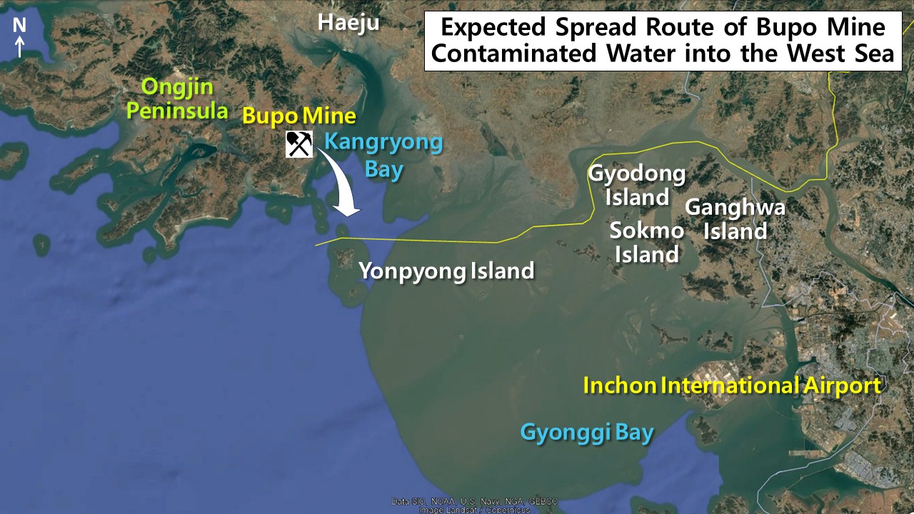
If pollutants reach the nearby farmland and reservoir, they could degrade soil and water quality and affect crop growth. If they spread to the adjoining Bupo saltworks, they could also affect the salt production environment and the safety of the solar salt produced there. Should the contaminated runoff reach the tidal flats and coastal fish farms off Bupo village, it could harm the coastal ecosystem and raise the risk of seafood contamination.
The yellow-tinted drainage collecting broadly across the farmland, reservoir and saltworks appears able, based on the area’s terrain, to exit into Kangnyong Bay through the sluice gates and floodgates installed in the tidal flats. If it flows into the Yellow Sea through Kangnyong Bay, it could spread to surrounding waters along tidal and coastal currents, and whether it could reach South Korean waters such as Gyeonggi Bay would need to be verified through precise ocean current modeling. Continued observation and analysis are needed to determine how the Bupo mine’s drainage is affecting Kangnyong Bay and the wider Yellow Sea coastal environment.
August 26, 2026 at 08:03PM
by DailyNK(North Korean Media)