
Thermal infrared satellite data collected in late May 2026 confirms that significant heat stress had already taken hold in both Pyongyang and Seoul well before the peak of summer, with Pyongyang’s power shortages leaving North Korean people with little ability to cope.
With forecasters predicting an unusually hot summer across the Korean peninsula, I analyzed precision thermal infrared (TIR) data captured by Landsat 8 and 9, NASA and USGS earth observation satellites, to assess surface temperature conditions in both capitals as of late May. The analysis finds that surface temperatures in Seoul averaged 30°C and in Pyongyang 28°C, with Seoul showing a significantly broader area under heat-warning conditions. Seoul’s higher readings reflect its lower latitude and closer proximity to the equator, which means it receives more solar energy per unit of surface area than Pyongyang. Seoul’s denser urban infrastructure compounds this, with asphalt and concrete absorbing and retaining daytime heat.
It is important to note what this satellite data measures and what it does not. The figures here are land surface temperatures (LST), captured by the satellite’s thermal infrared camera looking directly at the ground, and not the air temperature readings that meteorological agencies report from sensors positioned 1.5 meters above the ground in shade. Urban surfaces such as asphalt and concrete absorb solar radiation and can run 10 to 20°C or more above ambient air temperature. This means that when air temperatures reach the 33°C to 38°C range that meteorological agencies classify as a heat warning, satellite-observed surface temperatures in city centers can exceed 40°C and approach 50°C. The four-tier heat alert classification used in this analysis follows the standard framework: “attention” (31°C or above), “caution” (33°C or above), “warning” (35°C or above), and “danger” (38°C or above). Satellite analysis is particularly useful for identifying precisely which urban zones are accumulating the most heat and are most vulnerable to urban heat island effects.
Pyongyang: heat building before summer began
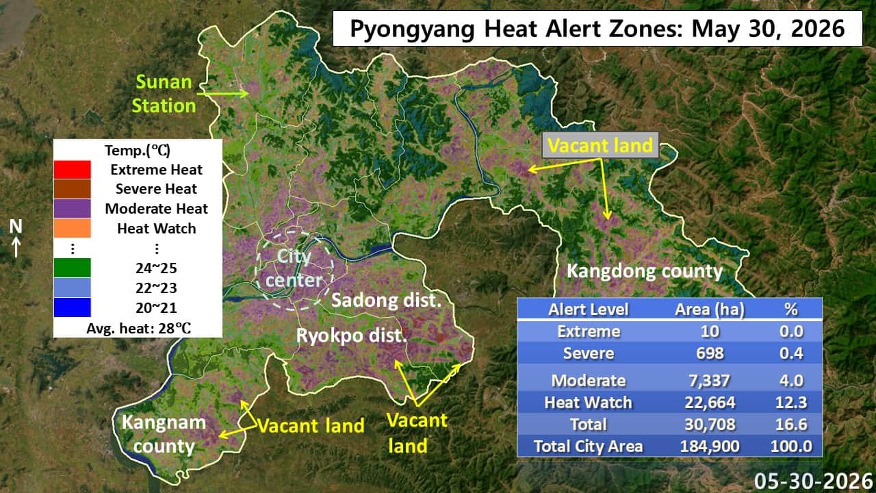
Landsat 9 data from May 30 shows that 16.6% of Pyongyang’s total area was already registering surface temperatures at or above the “attention” threshold. The “danger” category remained minimal, but the “warning” zone covered 698 hectares and the “caution” zone covered 7,337 hectares. The “attention” zone was broadly distributed across the city, signaling that preparations for heat were already necessary across much of Pyongyang before the summer season had officially begun.
The most intense heat concentrations appeared in the densely built city center and in open vacant lots where there is no shade to moderate surface temperatures. The central districts of Pyongyang and the Sadong and Ryokpo neighborhoods to the southeast of the Taedong River showed up in satellite imagery in purple (“caution”) and red (“warning”), driven by the heat-absorbing properties of artificial surfaces and asphalt. Vacant land in Sadong, Ryokpo, Kangnam county to the south, and Kangdong county to the east registered sharply elevated temperatures compared with the cooler, forested areas surrounding them.
The contrast is consistent: densely vegetated and forested areas maintained surface temperatures between 20 and 25°C, while concrete city centers and exposed vacant lots concentrated “caution” and “warning”-level heat islands. This data, captured before summer had even begun, demonstrates that heat is already accumulating intensely in specific development zones and on vacant land. It points to an urgent need for targeted heat mitigation measures in the most vulnerable areas, including the installation of shading structures and temporary green space.
Seoul: a wider and more intense heat footprint

Landsat 8 data from May 31 shows that 28.8% of Seoul’s total area had already entered heat-alert conditions, with the city averaging 30°C. The “danger” zone covered 142 hectares, the “warning” zone 769 hectares, and the “caution” zone 2,246 hectares. The “attention” zone extended across a striking 14,253 hectares, confirming that urban heat island effects were already in full force across the city before the start of summer.
The most intense concentrations of heat appeared in the densely populated traditional city center, covering Jongno, Jung, and Yongsan districts, and extending into Dongdaemun district and, south of the Han River, into Yeongdeungpo and Songpa districts, all densely marked in “caution”-level purple in satellite imagery. Particularly striking were the Gimpo Airport runway complex in Gangseo district, where enormous asphalt surfaces registered “danger” and “warning”-level red and brown, and the Garak Market wholesale complex in Songpa district, which showed severe heat accumulation across its large paved footprint.
By contrast, the forested mountain areas at the city’s edges, including Bukhansan to the north and Gwanaksan to the south, showed cool blue and green tones ranging from 15 to 25°C. The Han River corridor also appeared in satellite imagery as a meaningful cooling channel running through the city’s heat landscape.
Seoul vs. Pyongyang: same heat, very different consequences
The fundamental driver of Seoul’s higher surface temperatures is geographic: Seoul sits at a lower latitude than Pyongyang, placing it closer to the equator and causing it to receive more solar radiation per unit of surface area. Seoul’s far denser urban infrastructure amplifies this baseline difference through the urban heat island effect.
But the critical distinction between the two cities is not in their surface temperatures. It is in the ability of their populations to cope with heat. Seoul’s residential, commercial, and public transit environments are equipped with modern air conditioning, humidity control, and thermal insulation that effectively shield people from outdoor heat. No matter how high temperatures climb outside, well-functioning indoor cooling infrastructure means that heat exposure for most Seoul residents is manageable.
Pyongyang’s situation is fundamentally different. Although its higher latitude produces somewhat cooler baseline conditions and its surrounding forests help moderate temperatures, chronic power shortages mean that cooling and heating infrastructure frequently fails to operate. North Korean people are left to endure summer heat both outdoors and indoors, with few reliable means of relief. Climate change is intensifying this vulnerability. The satellite data shows that surface temperatures in Seoul are higher, but in terms of the real burden of heat on daily life, it is the people of Pyongyang who bear the greater weight.
June 16, 2026 at 07:20PM
by DailyNK(North Korean Media)